


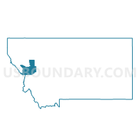
Precinct 20, Missoula County, Montana
About
Outline

Summary
| Unique Area Identifier | 612176 |
| Name | Precinct 20 |
| County | Missoula County |
| State | Montana |
| Area (square miles) | 262.74 |
| Land Area (square miles) | 261.91 |
| Water Area (square miles) | 0.83 |
| % of Land Area | 99.69 |
| % of Water Area | 0.31 |
| Latitude of the Internal Point | 47.12847650 |
| Longtitude of the Internal Point | -114.46287510 |
Maps


Graphs
Select a template below for downloading or customizing gragh for Precinct 20, Missoula County, Montana


Neighbors
Neighoring Voting District (by Name) Neighboring Voting District on the Map
- Precinct 10, Sanders County, MT
- Precinct 14, Missoula County, MT
- Precinct 18, Missoula County, MT
- Precinct 19, Missoula County, MT
- Precinct 21, Missoula County, MT
- Precinct 8, Sanders County, MT
- Precinct 9, Sanders County, MT
Top 10 Neighboring County Subdivision (by Population) Neighboring County Subdivision on the Map
- Flathead Reservation CCD, Lake County, MT (25,580)
- Lolo CCD, Missoula County, MT (14,611)
- Frenchtown-Wye CCD, Missoula County, MT (7,448)
- Plains CCD, Sanders County, MT (3,544)
- Superior CCD, Mineral County, MT (2,206)
- Flathead Reservation CCD, Sanders County, MT (1,881)
- Alberton CCD, Mineral County, MT (801)
Top 10 Neighboring Place (by Population) Neighboring Place on the Map
Top 10 Neighboring Elementary School District (by Population) Neighboring Elementary School District on the Map
- Target Range Elementary School District, MT (3,531)
- Arlee Elementary School District, MT (2,530)
- Dixon Elementary School District, MT (460)
- Paradise Elementary School District, MT (343)
- Camas Prairie Elementary School District, MT (172)
Top 10 Neighboring Secondary School District (by Population) Neighboring Secondary School District on the Map
- Missoula High School District, MT (100,417)
- Plains High School District, MT (3,425)
- Arlee High School District, MT (2,530)
- Charlo High School District, MT (1,792)
- Hot Springs High School District, MT (1,439)
Top 10 Neighboring Unified School District (by Population) Neighboring Unified School District on the Map
- Frenchtown K-12 Schools, MT (6,582)
- Superior K-12 Schools, MT (2,275)
- Alberton K-12 Schools, MT (1,371)
Top 10 Neighboring State Legislative District Lower Chamber (by Population) Neighboring State Legislative District Lower Chamber on the Map
- State House District 14, MT (10,552)
- State House District 100, MT (9,738)
- State House District 15, MT (9,595)
Top 10 Neighboring State Legislative District Upper Chamber (by Population) Neighboring State Legislative District Upper Chamber on the Map
- State Senate District 50, MT (21,523)
- State Senate District 7, MT (20,946)
- State Senate District 8, MT (19,081)
Top 10 Neighboring 111th Congressional District (by Population) Neighboring 111th Congressional District on the Map
Top 10 Neighboring Census Tract (by Population) Neighboring Census Tract on the Map
- Census Tract 16, Missoula County, MT (7,448)
- Census Tract 1, Sanders County, MT (3,544)
- Census Tract 9.02, Missoula County, MT (2,337)
- Census Tract 9646, Mineral County, MT (2,136)
- Census Tract 9645, Mineral County, MT (2,087)
- Census Tract 9407, Lake County, MT (1,996)
- Census Tract 9403, Sanders County, MT (1,881)
Top 10 Neighboring 5-Digit ZIP Code Tabulation Area (by Population) Neighboring 5-Digit ZIP Code Tabulation Area on the Map
- 59808, MT (17,904)
- 59804, MT (7,533)
- 59859, MT (3,270)
- 59821, MT (2,377)
- 59872, MT (2,309)
- 59834, MT (2,240)
- 59846, MT (1,617)
- 59820, MT (1,361)
- 59831, MT (454)
- 59856, MT (347)